
Orange and yellow pixels flash over American drilling heartlands around the Gulf Coast, New Mexico, and Pennsylvania. Dark red stretches across Middle East and China, while disturbing dots of color pop up around Greenland’s coast. This is the dangerous world of atmospheric methane emissions, one of the most powerful drivers of global warning—and it’s visible to the public for the first time. GHGSat Inc. released a new methane map on Wednesday that uses data from the company’s two satellites, which were launched earlier this year and can detect methane emitted by oil and gas wells, coal mines, power plants, farms and factories. It’s part of a wave of climate surveillance that will make it possible to hold countries and companies accountable for meeting targets to reduce and eventually eliminate planet-warming pollution.
“We’ve got a situation where for more than the last decade there’s been a significant and unexplained upward tick in global methane atmospheric concentrations,” said Jonathan Elkind, a senior research scholar at Columbia University’s Center on Global Energy Policy. In a paper published last week, Elkind outlined the way satellite-driven transparency will better allow investors to identify which companies aren’t backing their goals with action.
The early readings cover the lockdowns that aimed to slow the Covid-19 pandemic, which devastated demand for oil and sent methane emissions lower. Intensification on the map shows how quickly methane can build during the hot summer months in the Northern Hemisphere, with orange and red pixels along the Arctic coast and around Beijing.
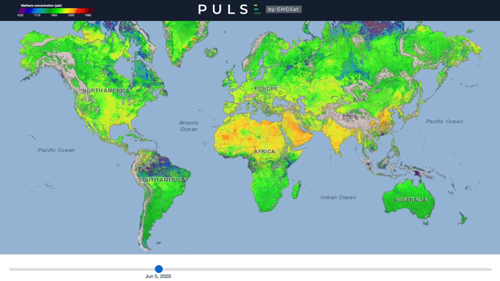
The map identifies concentration of methane across the troposhere, where naturally occurring emissions such as from wetlands mingle with those caused by human activity. Mountains can be seen trapping methane, such as in Southern California near the Sierra Nevada range or in South Asia below the Himalayas. Methane is more than 80 times more potent than carbon dioxide over a 20-year period, although its greenhouse impact fades much faster.
GHGSat claims its satellite offers the highest-resolution methane data publicly available, and the it sells access to companies ranging from Royal Dutch Shell Plc to landfill operators. In the next year, GHGSat plans to release additional data that will also quantify emissions, said Stephane Germain, president of the Montreal-based firm. That will make it clear how much methane is released by drilling in the U.S. Permian Basin every week, for example. The company is also developing a carbon dioxide-monitoring satellite that may be launched into orbit in 2022.
Satellite data will ultimately transform the way nations are held accountable for voluntary commitments under the Paris Agreement, which calls for limiting global average temperatures from rising more than 1.5 degrees Celsius above pre-industrial levels. Granular data that can pinpoint emissions down to specific facilities will also help track corporate emissions. “Very soon nobody is going to be able to hide from methane leakage,” former BP Plc Chief Executive Officer Bob Dudley predicted in 2018.