
A new payload that Elon Musk’s SpaceX will deliver into orbit next month will play a pivotal role in measuring sea level increases, potentially helping to spare economies from billions of euros in damages by the end of this century. The Sentinel-6 Michael Freilich satellite lifts off Nov. 10 aboard a Falcon 9 rocket that will be launched from Vandenberg Air Force Base in California. Its mission will be to track how the accelerating rise of sea levels are changing coastlines, threatening the habitat of more than a third of the world’s population. The European Space Agency will provide details about the mission on Friday at 4 p.m. in Paris.
“Measurements of global and regional sea level have become a valuable tool for decision makers to assess one of the most compelling impacts of climate change and how to prepare for flooding of coastal areas,” said Paul Counet, strategy chief at EUMETSAT. His 30-nation meteorological consortium is in charge of operating Sentinel-6 and crunching the 300 gigabytes of data that will be produced daily by the satellite.
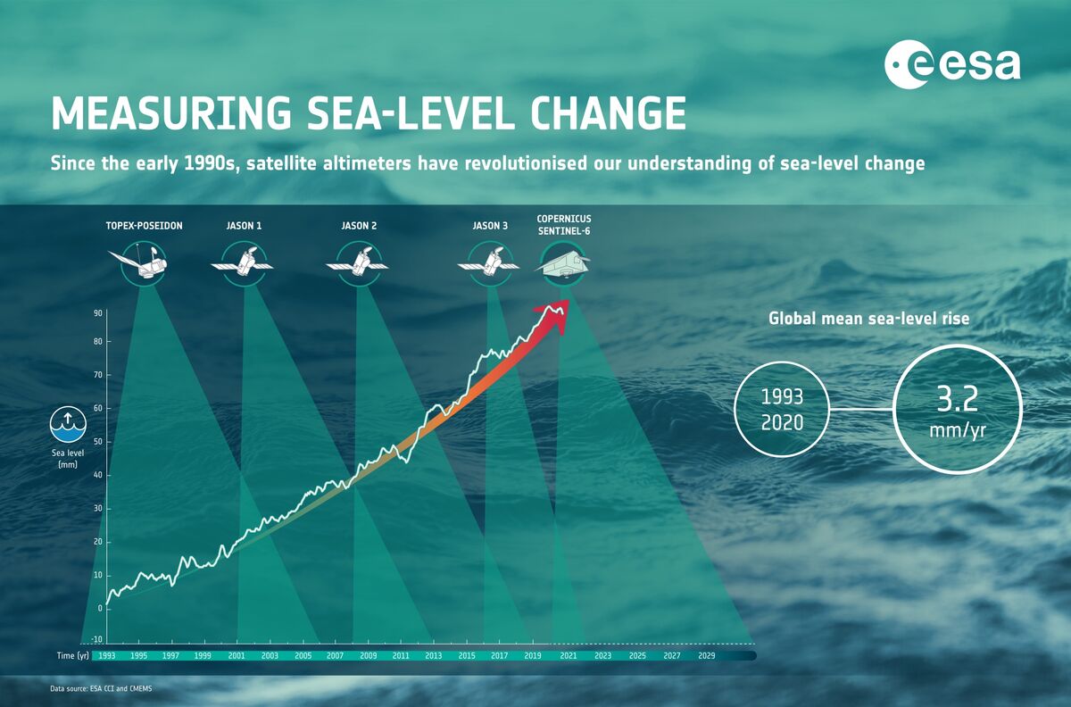
Sentinel-6 will update maps of the oceans covering 70% of the planet every 10 days. The satellite is packed with powerful new digital altimeters — instruments that bounce electromagnetic pulses off the globe’s surface to detect millimeter-scale changes in elevation. Engineers at the European Space Agency, along with the National Aeronautics and Space Administration developed the mission.
NASA contracted Musk’s Space X to launch the payload into an orbit 1,336 kilometers (830 miles) above Earth. The reusable first stage of the Falcon 9 rocket is expected to fly back to and touch down vertically next to the launch site at Vandenberg, said Tim Dunn, NASA’s launch director for Sentinel-6. SpaceX has re-flown 39 rockets from 93 total launches to date, according to the company’s website.
“Altimetry allows us to explore the current mean sea level and how this changes in space and time, something not trivial at all,” said Michalis Vousdoukas, an oceanographer who uses the data to estimate the economic costs of climate change. “All this information is fed in our models and allows us to analysis future water levels, areas flooded, as well as the resulting economic losses and the potential adaptation measures.”
If economies don’t dramatically curtail fossil fuel consumption, Europe’s coastlines could face as much as 239 billion euros ($280.6 billion) in damage annually from sea level rise by the end of this century, according to study published in May by Vousdoukas and his team of researchers. They estimate yearly damages could swell eight-fold to 12 billion euros — even under the best-case scenarios where temperature increases are kept well below the 2-degree Celsius (3.6 degree Fahrenheit) threshold mandated by the Paris Agreement.